Category: Geography


Fourth Standard

Subject:-Geography

Topic:- Our Maharashtra State

Subtopic:-About State

Source:- Wikipedia

About State

                                          Maharashtra is a state in the Southwestern region of India. It is the second most populous state after Uttar Pradesh and third largest state by area in India. Maharashtra is the wealthiest state in India, contributing 15% of the country’s industrial output and 13.3% of its GDP (2006–2007 figures).

Maharashtra is bordered by the Arabian Sea to the west,  Gujarat and the Union territory of Dadra and Nagar Haveli to the northwest, Madhya Pradesh to the northeast, Chhattisgarh to the east, Karnataka to the south, Andhra Pradesh to the southeast, and Goa to the southwest. The state covers an area of 307,731 km2  (118,816 sq mi) or 9.84% of the total geographical area of India. Mumbai, the capital city of the state, is India’s largest city and the financial capital of the nation. Nagpur is the second capital of the state. Marathi is the official language.

  • Religion:-

Hinduism:- Hindus form 83.2% of total population and Hinduism plays an important role in Maharashtrian people in their day-to-day life. Ganesh is the most popular deity amongst Marathi Hindus, followed by Krishna in the form of Vithal. They also worship the Shiva Family deities such as Shankar and Parvati. The Warkari tradition holds strong grip on local Hindus of Maharastra. The public Ganesh festival started by Lokmanya Tilak in the late 19th century is very popular. Marathi Hindus also revere Bhakti saints of all castes, such as Dnyaneshwar (Deshastha Brahmin), Savata Mali (Mali), Tukaram (Moray Maratahi-Kunbi), Namdev (Shimpi-Artsian,Vaishya) and Chokhamela (Mahar) and Banjara (Laman,Gormati).

Islam:-Islam is the second biggest religion in the state, with more than 11 million adherents comprising over 10% of the population. Eid-ul-Fitr (Ramzan Eid) and Eid-ul-Azha (Baqara Eid) are the most important Muslim festivals in the state. Within Muslims, Sunnis represent an overwhelming majority with an estimated 98% Muslims adhering to the Sunni Hanafi branch of Islam. Muslims follow Sufi traditions. Visiting the tombs of Sufi saints is very important to this community.

Jains:- Jainists are a major group in Maharashtra. Jain community census for 2001 in Maharashtra area was 1,301,843. Cultural roots on Maharashtra for Jainism explain this numbers, as this more than 2,500 year old religion has some ancient temples in Maharashtra.

Christians:-Christians account for 1,058,313 of Maharashtra’s population. Most of the Christians are Catholics, some Protestants. There are also Goan, Mangalorean, Keralite and Tamilian Christians in the urban pockets of Mumbai and Pune. There are two ethnic Christian communities in Maharashtra:

  • East Indians – Majority Catholics, concentrated in Mumbai and in the neighbouring districts of Thane and Raigad. St Bartholomew preached to the natives of this region in the 1st century AD.
  • Marathi Christians – Majority Protestants found specially in Ahmednagar and Solapur. Protestantism was brought to these areas by American and Anglican missionaries during the 18th century. Marathi Christians have largely retained their pre-Christian practices.
  • Parsis, mainly found in Mumbai, have descended from a group of Iranian Zoroastrians who immigrated to Western India during 10th century AD, due to persecution by Muslims in Iran.
  • Iranis, are comparatively recent arrivals, and represent the smaller of the two Indian-Zoroastrian communities.

Sikhism:- Sikhism is India’s fourth-largest religion and has existed for over 500 years, beginning with the birth of its founder Guru Nanak Dev ji. The Sikhs are predominantly located in Punjab, however the sikh community has a sizeable presence in Maharashtra. Sikh community census for 2001 in Maharashtra was 2,15,337. Nanded, the second largest city in the Marathwada region (after Aurangabad) of Maharashtra, is an important holy place for the Sikh faith and is famous for theHazur Sahib Gurudwara. Hazūr Sāhib (“presence of the master”), also spelled Hazoor Sahib, is one of the five takhts (seats of temporal authority) in Sikhism. Located on the banks of the River Godavari, it is where the 10th guru, Guru Gobind Singh Ji left human flesh. The Gurudwara within the complex is known Sach-Khand, “Realm of Truth”. At a stone-throw distance from the Hazoor Sahib Gurudwara, there lies the Langar Sahib Gurudwara which is very famous for its grand Langar. In all teh city boasts of 13 major Gurudwaras with historic significance.

Buddhism:-Most Marathi Buddhists are followers of the Dalit Buddhist movement, a 19th and 20th-century Buddhist revival movement in India that received its most substantial impetus from B. R. Ambedkar who called for the conversion of Dalits to Buddhism to escape a caste-based society that considered them to be the lowest in the hierarchy.[45] Buddhism accounts for nearly 6% in Maharastra’s total population.

Zoroastrians:- There are two Zoroastrian communities in Maharahtra.

Their descendants culturally and linguistically closer to the Zoroastrians of Iran, in particular to the Zoroastrians of Yazd and Kerman. Consequently, the Dari dialect of the Zoroastrians of those provinces may also be heard amongst the Iranis.

About State:- The Bene Israel (“Sons of Israel”) are a 6,000 strong community of Marathi Jews originally from villages in the Konkan region who migrated in the late 17th century to the nearby cities, primarily Mumbai, but also to Pune, and Ahmedabad. Prior to these waves of emigrations and to this day, the Bene Israel formed the largest sector of the subcontinent’s Jewish population. The native language of the Bene Israel is Marathi and Hebrew. Most Bene Israel have now emigrated to Israel. Before the migration this community numbered at least 30,000.

  • Festivals:-
  • wari

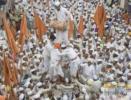
1) Aashadi Ekadashi is one of most important festivals celebrated across Maharashtra. It is also referred to as “WARI” and people from all over Maharashtra, Karnataka and other parts of India walk to Pandharpur from there respective villages.

ganesh_utsav_mumbai

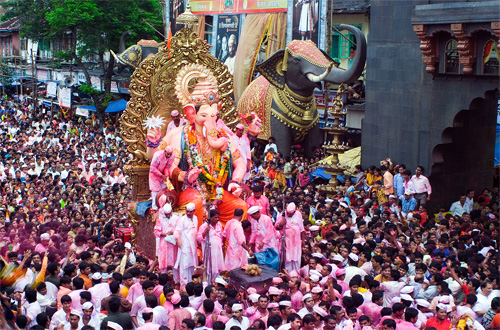
2)Lord Ganesha’s devotion is celebrated by Ganesh Chaturthi in August–September of every year. Town of Pen in Raigad district is famous for Ganesh Idols made of special Shadu Clay. Dagdusheth Halwai Ganpati, Lalbaugcha Raja, Shri Siddhivinayak Temple, Shri Ashtavinayaka’s are the major holy places for Maharashtrians.

3)Popular forms of God are Shiva, Krishna and Ganesha. Lord Shiva’s devotion is celebrated by taking part in Maha Shivaratri (Great Night of Shiva) festival. In modern times, the Elephanta island in Mumbai, Lord’s Shiva island in local mythology, originated the Elephant Festival.

4)Lord Krishna’s devotions are celebrated in the state-wide Gokul Ashtami (or Krishna Janmashtami, Krishna’s birthday) whereby many devotees fast on the entire day until midnight. The Dahi-Handi (Matki-fod) is also observed on this day at many places. Lord Krishna’s devotion are also celebrated at Kaartik Aamawasya (orDiwali) and at Narak Chaturdashi as the killing of the demon Narakasura.

5)The other festivals celebrated on a large scale are Vijayadashami or Dasara (Marathi: दसरा), Navaratri, Holi, Diwali, Eid (Ramzan Eid). Simollanghan is a ritual performed on Dasara or Viajaya Dashami day in Maharashtra. Simollanghan is crossing the border or frontier of a village or a place. In ancient times, kings used to cross the frontier of their kingdom to fight against their rivals or neighbor kingdoms. They used to perform Ayudha Puja on Dasara and begin the war season. On Dasara, people cross the borders of their places (Seemollanghan) and collect the leaves of Apta tree (आपट्याची पाने) and exchange among their friends and relatives as gold (सोने म्हणून आपट्याची पाने देतात).People worship Shami tree and its leaves (शमीची पाने) on this day.

Saints (संत):-

Maharashtra has produced or been closely associated with many  saints  throughout its history. These have risen from all across the several castes. Some of the very revered examples of Bhakti saints are Dnyaneshwar, Tukaram, Namdev, sant Gora Kumbhar, Samarth Ramdas, Chokhamela, and Savta Mali. There have also been several other Harijan saints such as Sant Banka Mahar, Sant Bhagu, Sant Damaji panth, Sant Kanhopatra, Sant Karmamelam, Sant Nirmala, Sant Sadna, Sant Sakhubai, Sant Satyakam Jabali, Sant Soyarabai, and Sant Eknath. It has also been the birthplace and home of world-reputed saints like Sai Baba of Shirdi, Gajanan Maharaj of shegaon, Swami Shukadas Maharaj, Swami Samarth Maharaj, and Meher Baba, whose tomb-shrine in Meherabad has become a place of world pilgrimage. Maharashtra is also equally famous for ardent devotees (or Bhaktas). For example, Namdev Mahar and his wife Bhagubai from Kharagpur are both devotees of Shirdi Sai Baba. The Sai Baba template in Shirdi is the second richest one in the country, a close second after the Lord Tirupati temples at Tirumala, Andhra Pradesh. And Sant Sevalal Maharaj.

  • Languages:-

Marathi is the Official language of Maharashtra. According to 2001 census, it is mother tongue of 68.89% of the population. Other languages which are Mother tongue by more than one percent of the people are as follows

Language

Percentage in state
Marathi 68.89
Urdu 7.13
Hindi 2.04
Kannada 11.50
Gujarati 2.39
Telugu 7.05
Other languages

1.05

 Maharashtrian (or Marathi) cuisine :-

Mahrashtrian Thali

It is cuisine of the Marathi people, those from the state of Maharashtra in India. Maharashtrian cuisine covers a range from being mild to very spicy dishes. Wheat, rice, jowar, bajri, vegetables, lentils and fruit form important components of Maharashtrian diet.

Regular meals and Staple dishes:-

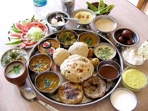
Maharashtrian meals (mainly lunch and dinner) are served on a plate called thali. Each food item served on the thali has a specific place. The bhaaji is served in the plate on the right hand side while the chutney, koshimbir are served from left going up the periphery of the circular plate. The papad, bhaaji are served below the koshimbir with the rice and poli served at the bottom of the circle closed to the diner’s hand. The puran is served at the top in the inner concentric circle. The amti, rassa is served in separate bowls placed on right hand side of the diner. Water is placed on the left hand side. It is considered ill mannered to use left hand while eating.

A typical Maharashtrian lunch or dinner usually starts with Poli (chapati), accompanied by one or more bhaaji(s) (cooked vegetables) and a koshimbir(vegetable salad) along with some sides(usually pickles, Chutneys, or papad (Poppadom)). This is usually followed by a second course of varan(lightly or unspiced Daal preparation), aamti (spicy Daal preparation) or rassa with rice. As with most of Indian cuisine however, each region and /or community has its own quirks, preferences and variations of the above general format.

koshimbir

Koshimbir is very common and healthy addition to the plate. Typically made from raw vegetables mixed with yogurt and ground roasted peanuts (Danyache Kut). Raitas made with different types of vegetables such as cucumber or carrots are variants of koshimbir.

There are lots of snack and side dishes in Maharashtrian cuisine. Some quintessentially Maharashtrian dishes are Poha, Chivada, Upma, Surali Wadi, Vada Pav, Misal, Matar Usal, Thalipith, Bhadang, Bakarwadi etc.Sweets/Desert like Puran Poli,Gulachi Poli,Modak,Karanji, Gulabjam, Kheer,Chirota, Gilabi etc.are most famous in Maharastra.

  • Divisions and regions:-

Maharashtra is divided into six revenue divisions, which are further divided into thirty-five districts. These thirty-five districts are further divided into 109 sub-divisions of the districts and 357 Talukas in Maharashtra. The six administrative divisions in Maharashtra state are Amravati Division, Aurangabad Division,Konkan Division, Nagpur Division, Nashik Division, and Pune Division.

Division Districts
Mumbai (Konkan) Mumbai, Mumbai Suburban (Mumbai Upanagar), Thane, Raigad, Ratnagiri, and Sindhudurg
Pune Pune, Satara, Sangli, Solapur, and Kolhapur
Nashik Nashik, Dhule, Jalgaon, Ahmednagar, and Nandurbar
Aurangabad Aurangabad, Jalna, Latur/Lattalur, Nanded, Osmanabad, Parbhani, Hingoli, and Beed
Amravati Amravati, Akola, Washim, Buldhana and Yavatmal
Nagpur Nagpur, Chandrapur, Wardha, Bhandara, Gondia, and Gadchiroli

Geographically, historically and according to political sentiments, Maharashtra has five main regions:

  • Vidarbha Region – (Nagpur and Amravati divisions) – (Central Provinces and Old Berar Region)
  • Marathwada Region – (Aurangabad division)
  • Khandesh and Northern Maharashtra Region – (Nashik Division)
  • Desh or Western Maharashtra Region – (Pune division) and
  • Konkan Region – (Konkan Division) – (including, Mumbai City and Mumbai Suburban Area).

The state capital Mumbai City and Mumbai Suburban Area are the parts of the Konkan Division

  • Transport:-

1)Roads

Maharashtra has the largest road network in India at 267,452 kilometers.           17 National Highways connect Maharashtra to six neighbouring states. The length of National Highways in Maharashtra is 3688 kilometers. Maharashtra has a large state highway network. 97.5 per cent of the villages in the state were connected by all-weather roads as of March 2010. The Yeshwantrao Chavan Mumbai-Pune Expressway, the first access controlled toll road project in India was made fully operational in April 2002.

The Maharashtra State Road Transport Corporation (MSRTC) has been providing passenger road transport service in the public sector since 1948, linking most of the towns and villages in and around the state with a large network of operation. These buses, popularly called ST (State Transport), are the preferred mode of transport for much of the populace.

2)Railways

The state is well-connected to other parts of the country with a railway network spanning 5,983 km between four Railways.

  • The Central Railway and the Western Railway zones of the Indian Railways that are headquartered in Mumbai, at Chhatrapati Shivaji Terminus and Churchgate respectively,
  • The Nanded division of the South Central Railway that caters to the Marathwada region of Maharashtra and
  • The Konkan Railway, a subsidiary of the Indian Railways based in CBD Belapur, Navi Mumbaithat serves the Konkan coastal region south of Mumbai and continues down the west coast of India.

Maharashtra also has suburban railway networks that carry around 6.4 million passengers every day.

3) Civil Aviation

The booming Indian economy, growing tourism industry, entry of low cost airlines, liberalization of international bi-lateral agreements and liberalization of civil aviation policy at the centre has resulted in an unprecedented growth in air traffic. Most of the State’s airfields are operated by the Airports Authority of India (AAI) while Reliance Airport Developers (RADPL), currently operate five non – metro airports at Latur, Nanded, Baramati, Osmanabadand Yavatmal on a 95 year lease. The Maharashtra Airport Development Company Limited (MADC) that was set up by the Government in 2002 will take up development of Airports in the state that are not under the AAI or the  Maharashtra Industrial Development Corporation(MIDC). MADC is playing the lead role in the planning and implementation of the Multi-modal International Cargo Hub and Airport at Nagpur (MIHAN) project.

Maharashtra has three international airports-

  • Mumbai’s Chhatrapati Shivaji International Airport (among the busiest airports in India)
  • Pune’s civil enclave international airport with flights to Dubai and Frankfurt
  • Nagpur’s Dr. Babasaheb Ambedkar International Airport.

Other city airports such as, Aurangabad and Nanded, are served by scheduled domestic services.

4) Sea Ports

Maharashtra has three major ports at Mumbai (operated by the Mumbai Port Trust), the JNPT lying across the Mumbai harbour in Navi Mumbai, and in Ratnagiri, which handles the export of ores mined in the Maharastra hinterland. Additionally, there are 53 minor ports. Ferryboat services also operate at Mumbai, linking the city to neighbouring coastal towns. Minor ports in the state will be developed by the State government with the participation of the private sector under the Maharashtra Maritime Board. Seven minor ports are being developed in Phase-I.

  • Culture:-

Marathi is the official language of Maharashtra. Maharashtrians take great pride in their language and history, particularly the Maratha Empire, its founder Chhatrapati Shivaji Maharajis considered a folk hero across India. About 60% of Maharashtrians are Hindu, and there are significant Muslim, Christian and Buddhist minorities. There are many temples in Maharashtra some of them being hundreds of years old. These temples are constructed in a fusion of architectural styles borrowed from North and South India. The temples also blend themes from Hindu, Buddhist and Jain cultures. A National Geographicedition reads, “The flow between faiths was such that for hundreds of years, almost all Buddhist temples, including the ones atAjanta, were built under the rule and patronage of Hindu kings.” The temple of Vitthal at Pandharpur is the most important temple for the Varkari sect. Other important religious places are the Ashtavinayaka temples of Lord Ganesha, Bhimashankar which is one of the Jyotirling(12 important Shiva temples).  Ajanta and Ellora caves near Aurangabad as well as Elephanta Caves near  Mumbai  are UNESCO World Heritage Sites and famous tourist attractions. Mughal architecture can be seen is the tomb of the wife of Aurangzeb called Bibi Ka Maqbara located at Aurangabad.

Maharashtra, like other states of India, has its own folk music. The folk music viz. Gondhal, Lavani, Bharud and Powada are popular especially in rural areas, while the common forms of music from the Hindi and Marathi film industry are favoured in urban areas.

The world famous film industry Bollywood is in Maharashtra, located in the economic capital of India, Mumbai. The Marathi film industry was once placed in Kolhapur but now is spread out through Mumbai too. The pioneer of Indian movie industry, Bharat Ratna Shri Dadasaheb Phalke, producer & director V. Shantaram are from Maharashtra

Women traditionally wear a nine yard or five yard sari and men a dhoti  or  pajama with a shirt. This, however, is changing with women in urban Maharashtra wearing Punjabi dresses, consisting of a Salwar and a Kurta while men wear trousers and a shirt.

The cricket craze can be seen throughout Maharashtra, as it is the most widely followed and played sport. Kabaddi and hockey are also played with fervor. Children’s games include Viti-Dandu (Gilli-danda in Hindi) and Pakada-pakadi .

Hindus in Maharashtra follow the Shalivahana Saka era calendar. Gudi Padwa, Diwali, Rangapanchami, Gokulashtami and Ganeshotsavare some of the festivals that are celebrated in Maharashtra. Ganeshotsav is one of the biggest festival of Maharashtra which is celebrated with much reverence and festivity throughout the state and has since some time become popular all over the country. The festival which continues over ten days is in honour of Ganesha, the deva (like guardian angel ) of learning and knowledge under the one supreme lord . A large number of people walk hundreds of kilometers to Pandharpur for the annual pilgrimage in the month of Ashadh.

Fourth Standard

Subject:-Geography

Topic:- Natural Environment

Subtopic:-Biotic Component

Source:- Wikipedia

Biotic component

                                  ‘Biotic components’ are the living things that shape an ecosystem. A ‘biotic factor’ is any living component that affects another organism, including animals that consume the organism in question, and the living food that the organism consumes. Each biotic factor , neto abiotic components, which are non-living components of an organism’s environment, such as temperature, light, moisture, air currents, etc. Remember the abiotic factors by SWATS. Soil, Water, Air, Temperature, and Sunlight.

Biotic components usually include:

  • Producers, i.e. autotrophs: e.g. plants, they convert the energy [from photosynthesis (the transfer of sunlight, water, and carbon dioxide into energy), or other sources such as hydrothermal vents] into food.
  • Consumers, i.e. heterotrophs: e.g. animals, they depend upon producers (occasionally other consumers) for food.
  • Decomposers, i.e. detritivores: e.g. fungi and bacteria, they break down chemicals from producers and consumers (usually dead) into simpler form which can be reused.
    Supplement

    • Biotic factors are factors resulting from the activities of a living thing or any living component in an environment, such as the actions of an organism affecting the life of another  organism.
    • For instance, in a quail’s environment, the biotic factors are the living elements of the environment such as the quail’s prey like insects, seeds, etc. and the quail’s predators like coyotes

Fourth Standard

Subject:-Geography

Topic:- Natural Environment

Subtopic:-Abiotic Component

Source:- Wikipedia


Abiotic component

Abiotic Factors

                                       In ecology and biology, abiotic components (also known as abiotic factors) are non-living chemical and physical factors in the environment, which affect ecosystems. Abiotic phenomena underlie all of biology.

From the biological point of view, abiotic factors can be classified as light or more generally radiation, temperature, water, the chemical surrounding composed of the terrestrial atmospheric gases, as well as soil, rock,minerals. The macroscopic  climate  often influences each of the above.

Abiotic factors may be grouped into the following main categories:

  • Climatic factors – include sunlight, humidity, temperature, atmosphere, etc.
  • Edaphic factors – include the nature and type of the soil, geology of the land, etc.
  • Social factors – include land use, water resources, etc.

Abiotic factors are further investigated in the freshwater ecology tutorial.

Those underlying factors affect different plants, animals and fungi to different extents. Some plants are mostly water starved, so humidity plays a larger role in their biology. If there is little or no sunlight then plants may wither(सुकणे) and die from not being able to get enough sunlight to do photosynthesis. Many archaebacteria require very high temperatures, or pressures, or unusual concentrations of chemical substances such as sulfur, because of their specialization into extreme conditions. Certain fungi have evolved to survive mostly at the temperature, the humidity, and stability of their environment.

For example, there is a significant difference in access to water as well as humidity between temperate rainforests and deserts. This difference in water access causes a diversity in the types of plants and animals that grow in these areas.

Fourth Standard

Subject:-Geography

Topic:- Measurement of time

Subtopic:- Moon

Source:- Wikipedia


Moon

Full Moon

                                     The Moon is the only natural satellite(उपग्रह) of the Earth, and the fifth largest satellite in the Solar System. It is the largest natural satellite of a planet in the Solar System relative to the size of its primary, having 27% the diameter and 60% the density of Earth, resulting in 181 its mass. It is in  rotation with Earth while spinning around itself. The Moon is the brightest object in the sky after the Sun, although its surface is actually very dark, with a reflectance similar to that of coal. Its prominence(महत्व) in the sky and its regular cycle of phases have, since ancient times, made the Moon an important cultural influence on language, calendars, art and mythology.

The Moon’s gravitational influence produces the ocean tides and the minute lengthening of the day. The Moon’s current orbital distance, about thirty times the diameter of the Earth, causes it to appear almost the same size in the sky as the Sun, allowing it to cover the Sun nearly precisely in total solar eclipses(ग्रहण). This matching of apparent visual size is a coincidence. Earlier in Earth’s history, the Moon was closer to Earth, and would have had an apparent visual size greater than that of the sun.

The Moon is thought to have formed nearly 4.5 billion years ago, not long after the Earth. Although there have been several hypotheses for its origin in the past, the current most widely accepted explanation is that the Moon formed from the debris left over after a giant impact between Earth and a Mars-sized body. The Moon is the only celestial body other than Earth on which humans have set foot. The Soviet Union’s Luna programme was the first to reach the Moon with unmanned spacecraft in 1959; the United States’ NASA  Apollo program achieved the only manned missions to date, beginning with the first manned lunar orbiting mission by Apollo 8 in 1968, and six manned lunar landings between 1969 and 1972, with the first being Apollo 11. These missions returned over 380 kg of lunar rocks, which have been used to develop a geological understanding of the Moon’s origins, the formation of its internal structure, and its subsequent history.

After the Apollo 17 mission in 1972, the Moon has been visited only by unmanned spacecraft, notably by the final Soviet Lunokhod rover. Since 2004, Japan, China, India, the United States, and the European Space Agency have each sent lunar orbiters. These spacecraft have contributed to confirming the discovery of lunar water ice in permanently shadowed craters at the poles and bound into the lunar regolith. Future manned missions to the Moon have been planned, including government as well as privately funded efforts. The Moon remains, under the Outer Space Treaty, free to all nations to explore for peaceful purposes.

The tides on the Earth are mostly generated by the gradient in intensity of the Moon’s gravitational pull from one side of the Earth to the other, the tidal forces. This forms two tidal bulges on the Earth, which are most clearly seen in elevated sea level as ocean tides. Since the Earth spins about 27 times faster than the Moon moves around it, the bulges are dragged along with the Earth’s surface faster than the Moon moves, rotating around the Earth once a day as it spins on its axis.  The ocean tides are magnified by other effects: frictional coupling of water to Earth’s rotation through the ocean floors, the inertia of water’s movement, ocean basins that get shallower near land, and oscillations between different ocean basins. The gravitational attraction of the Sun on the Earth’s oceans is almost half that of the Moon, and their gravitational interplay is responsible for spring and neap tides.

Gravitational coupling between the Moon and the bulge nearest the Moon acts as a torque on the Earth’s rotation, draining angular momentum and rotational kinetic energy from the Earth’s spin.In turn, angular momentum is added to the Moon’s orbit, accelerating it, which lifts the Moon into a higher orbit with a longer period. As a result, the distance between the Earth and Moon is increasing, and the Earth’s spin slowing down.Measurements from lunar ranging experiments with laser reflectors left during the Apollo missions have found that the Moon’s distance to the Earth increases by 38 mm per year[105] (though this is only 0.10 ppb/year of the radius of the Moon’s orbit). Atomic clocks also show that the Earth’s day lengthens by about 15 microseconds every year,slowly increasing the rate at which UTC is adjusted by leap seconds. Left to run its course, this tidal drag would continue until the spin of the Earth and the orbital period of the Moon matched. However, the Sun will become a red giant long before that, engulfing the Earth.

The lunar surface also experiences tides of amplitude ~10 cm over 27 days, with two components: a fixed one due to the Earth, as they are insynchronous rotation, and a varying component from the Sun. The Earth-induced component arises from libration, a result of the Moon’s orbital eccentricity; if the Moon’s orbit were perfectly circular, there would only be solar tides. Libration also changes the angle from which the Moon is seen, allowing about 59% of its surface to be seen from the Earth (but only half at any instant). The cumulative effects of stress built up by these tidal forces produces moonquakes. Moonquakes are much less common and weaker than earthquakes, although they can last for up to an hour—a significantly longer time than terrestrial earthquakes—because of the absence of water to damp out the seismic vibrations. The existence of moonquakes was an unexpected discovery from seismometers placed on the Moon by Apollo astronauts from 1969 through 1972.


Fourth Standard

Subject:-Geography

Topic:- Measurement of time

Subtopic:- Solar Time Measurement

Source:- Wikipedia


Solar Time Measurement


In a Solar time measurement only motion of the Earth around Sun is used. In a solar calendar year is divided into 12 months. It has maximum 365 days.

The natural science of astronomy is the study of celestial(खगोलीय) objects, observations and phenomena in the night sky. The ancient discipline of astronomy is the key method of calculating a date and time. A star in a solar system is the source of light which creates the stellar day, the rotation period of orbiting planets regulates the seasons on a planet surface, this combination is monitored and recorded by a calendar.

If the position of the earth in its orbit around the sun is reckoned with respect to the equinox, the point at which the orbit crosses the celestial equator, then its dates accurately indicate the seasons, that is, they are synchronized with the declination of the sun. Such a calendar is called a tropical solar calendar.The duration of the mean calendar year of such a calendar approximates some form of the tropical year, usually either the mean tropical year or the vernal equinox year.

The following are tropical solar calendars:

  • Gregorian calendar
  • Julian calendar
  • Bahá’í calendar
  • Coptic calendar
  • Iranian calendar (Jalāli Calendar)

Every one of these calendars has a year of 365 days, which is occasionally extended by adding an extra day to form a leap year, a method called “intercalation”, the inserted day being “intercalary”.

Indian calendars like the Hindu calendar, Bengali calendar, Malayalam calendar and Tamil calendar are sidereal (नक्षत्र)solar calendars. The Thai solar calendar, based on the Hindu solar calendar is also a sidereal calendar. They are calculated on the basis of the apparent motion of the sun through the twelve zodiacs rather than the true tropical movement of the earth.

Fourth Standard

Subject:-Geography

Topic:- Measurement of time

Subtopic:- Lunisolar Time Measurement

Source:- Wikipedia


Lunisolar Time Measurement

                      In this type of time measurement the Earth’s annual motion is used to measure year & the Moon’s motion around Earth is used to measure month. All these calendars have a variable number of months in a year. The reason for this is that a year is not evenly divisible by an exact number of lunation, so without the addition of intercalary months the seasons would drift each year. This results in a thirteen-month year every three years.The Hindu calendars are Lunisolar

Some lunar calendars are calibrated by annual natural events which are affected by lunar cycles as well as the solar cycle. An example of this is the lunar calendar of the Banks Islands which includes three months in which the edible palolo worm mass on the beaches. These events occur at the last quarter of the lunar month, as the reproductive cycle of the palolos is synchronised with the moon.

Even though the Gregorian calendar is in common and legal use, lunar calendars serve to determine traditional holidays in parts of the world such as India,  China, Korea, Japan, Vietnam and Nepal. Some examples include Diwali, Chinese New Year/Tết (Vietnamese New Year), Mid-Autumn Festival/Chuseok and Nepal Sambat.


Fourth Standard

Subject:-Geography

Topic:- Measurement of time

Subtopic:- Lunar Time Measurement

Source:- Wikipedia


Lunar Time Measurement

                                    A Lunar Time Measurement is depends upon the motion of the Moon around the Earth. A lunar calendar is a calendar that is based on cycles of the lunar phase. A common purely lunar calendar is the Islamic calendar or Hijri Qamari calendar. A feature of the Islamic calendar is that a year is always 12 months, so the months are not linked with the seasons and drift each solar year by 11 to 12 days. It comes back to the position it had in relation to the solar year approximately every 33 Islamic years. It is used mainly for religious purposes, and in Saudi Arabia it is the official calendar. Because there are about twelve lunation (synodic months) in a solar year, this period (354.37 days) is sometimes referred to as a lunar year.

Lunar calendars differ as to which day is the first day of the month. For some lunar calendars, such as the Chinese calendar, the first day of a month is the day when an astronomical new moon occurs in a particular time zone. For others, such as some Hindu calendars, each month begins on the day after the full moon or the new moon. Others were based in the past on the first sighting of a lunar crescent, such as the Hebrew calendar.

The length of a month orbit/cycle is difficult to predict and varies from its average value. Because observations are subject to uncertainty and weather conditions, and astronomical methods are highly complex, there have been attempts to create fixed arithmetical rules.The average length of the synodic month is 29.530589 days. This requires the length of a month to be alternately 29 and 30 days (termed respectively hollow and full).

Fourth Standard

Subject:-Geography

Topic:- Maharashtra

Subtopic:-Water & Marine Resources

Point:- Water Resources

Source:- Wikipedia


Water resources

 Earth's_water_distribution.svg


A graphical distribution of the locations of water on Earth.

                       Water resources are sources of water that are useful or potentially useful. Uses of water include agricultural, industrial,household, recreational and environmental activities. Virtually all of these human uses require fresh water. 97% of the water on the Earth is salt water. However, only three percent is fresh water; slightly over two thirds of this is frozen in glaciers and polar ice caps. The remaining unfrozen freshwater is found mainly as groundwater, with only a small fraction present above ground or in the air.

Fresh water is a renewable resource, yet the world’s supply of clean, fresh water is steadily decreasing. Water demand already exceeds supply in many parts of the world and as the world population continues to rise, so too does the water demand. Awareness of the global importance of preserving water for ecosystem services has only recently emerged as, during the 20th century, more than half the world’s wetlands have been lost along with their valuable environmental services for Water Education.  The framework for allocating water resources to water users (where such a framework exists) is known as water rights.

Sources of fresh water

1] Surface water

Surface water is water in a river, lake or fresh water wetland. Surface water is naturally replenished by precipitation and naturally lost through discharge to the oceans, evaporation, evapotranspiration and sub-surface seepage.

Although the only natural input to any surface water system is precipitation within its watershed, the total quantity of water in that system at any given time is also dependent on many other factors. These factors include storage capacity in lakes, wetlands and artificial reservoirs, the permeability of the soil beneath these storage bodies, the runoff  characteristics of the land in the watershed, the timing of the precipitation and local evaporation rates. All of these factors also affect the proportions of water loss.

Human activities can have a large and sometimes devastating impact on these factors. Humans often increase storage capacity by constructing reservoirs and decrease it by draining wetlands. Humans often increase runoff quantities and velocities by paving areas and channelizing stream flow.

The total quantity of water available at any given time is an important consideration. Some human water users have an intermittent need for water. For example, many farms require large quantities of water in the spring, and no water at all in the winter. To supply such a farm with water, a surface water system may require a large storage capacity to collect water throughout the year and release it in a short period of time. Other users have a continuous need for water, such as a power plant that requires water for cooling. To supply such a power plant with water, a surface water system only needs enough storage capacity to fill in when average stream flow is below the power plant’s need.

Nevertheless, over the long term the average rate of precipitation within a watershed is the upper bound for average consumption of natural surface water from that watershed. Natural surface water can be augmented by importing surface water from another watershed through a canal or pipeline. It can also be artificially augmented from any of the other sources listed here, however in practice the quantities are negligible. Humans can also cause surface water to be “lost” (i.e. become unusable) through pollution.

Brazil is the country estimated to have the largest supply of fresh water in the world, followed by Russia and Canada.

2] Under river flow

Throughout the course of a river, the total volume of water transported downstream will often be a combination of the visible free water flow together with a substantial contribution flowing through sub-surface rocks and gravels that underlie the river and its floodplain called the hyporheic zone. For many rivers in large valleys, this unseen component of flow may greatly exceed the visible flow. The hyporheic zone often forms a dynamic interface between surface water and true ground-water receiving water from the ground water when aquifers are fully charged and contributing water to ground-water when ground waters are depleted. This is especially significant in karst areas where pot-holes and underground rivers are common.

3] Ground water

Sub-surface water, or groundwater, is fresh water located in the pore space of soil and rocks. It is also water that is flowing within aquifers below the water table. Sometimes it is useful to make a distinction between sub-surface water that is closely associated with surface water and deep sub-surface water in an aquifer (sometimes called “fossil water”).

Sub-surface water can be thought of in the same terms as surface water: inputs, outputs and storage. The critical difference is that due to its slow rate of turnover, sub-surface water storage is generally much larger compared to inputs than it is for surface water. This difference makes it easy for humans to use sub-surface water unsustainably for a long time without severe consequences. Nevertheless, over the long term the average rate of seepage above a sub-surface water source is the upper bound for average consumption of water from that source.

The natural input to sub-surface water is seepage from surface water. The natural outputs from sub-surface water are springs and seepage to the oceans.If the surface water source is also subject to substantial evaporation, a sub-surface water source may become saline. This situation can occur naturally under endorheic bodies of water, or artificially under irrigated farmland. In coastal areas, human use of a sub-surface water source may cause the direction of seepage to ocean to reverse which can also cause soil salinization. Humans can also cause sub-surface water to be “lost” (i.e. become unusable) through pollution. Humans can increase the input to a sub-surface water source by building reservoirs or detention ponds.

4] Desalination

Desalination is an artificial process by which saline water (generally sea water) is converted to fresh water. The most common desalination processes are distillation  and reverse osmosis. Desalination is currently expensive compared to most alternative sources of water, and only a very small fraction of total human use is satisfied by desalination. It is only economically practical for high-valued uses (such as household and industrial uses) in arid areas. The most extensive use is in the Persian Gulf.

5] Frozen water

Several schemes have been proposed to make use of icebergs as a water source, however to date this has only been done for novelty purposes. Glacier runoff is considered to be surface water.
Uses of fresh water

Uses of fresh water can be categorized as renewable and non-renewable . A use of water is consumptive if that water is not immediately available for another use. Losses to sub-surface seepage and evaporation are considered renewable, as is water incorporated into a product (such as farm produce). Water that can be treated and returned as surface water, such as sewage, is generally considered non-renewable if that water can be put to additional use. Water use in power generation and industry is generally described using an alternate terminology, focusing on separate measurements of withdrawal and consumption. Withdrawal describes the removal of water from the environment, while consumption describes the conversion of fresh water into some other form, such as atmospheric water vapor or contaminated waste water

1] Agricultural

It is estimated that 69% of worldwide water use is for irrigation, with 15-35% of irrigation withdrawals being unsustainable. It takes around 3,000 litres of water, converted from liquid to vapour, to produce enough food to satisfy one person’s daily dietary need. This is a considerable amount, when compared to that required for drinking, which is between two and five litres. To produce food for the now over 7 billion people who inhabit the planet today requires the water that would fill a canal ten metres deep, 100 metres wide and 7.1 million kilometres long – that’s enough to circle the globe 180 times.

2] Industrial

It is estimated that 22% of worldwide water is used in industry. Major industrial users include hydroelectric dams, thermoelectric power plants, which use water for cooling, ore and oil refineries, which use water in chemical processes, and manufacturing plants, which use water as a solvent. Water withdrawal can be very high for certain industries, but consumption is generally much lower than that of agriculture.

3] Household

It is estimated that 8% of worldwide water use is for household purposes. These include drinking water, bathing, cooking, sanitation, and gardening. Basic household water requirements have been estimated by Peter Gleick at around 50 liters per person per day, excluding water for gardens. Drinking water is water that is of sufficiently high quality so that it can be consumed or used without risk of immediate or long term harm. Such water is commonly called potable water. In most developed countries, the water supplied to households, commerce and industry is all of drinking water standard even though only a very small proportion is actually consumed or used in food preparation.

Water stress

The concept of water stress is relatively simple: According to the World Business Council for Sustainable Development, it applies to situations where there is not enough water for all uses, whether agricultural, industrial or domestic. Defining thresholds for stress in terms of available water per capita is more complex, however, entailing assumptions about water use and its efficiency. Nevertheless, it has been proposed that when annual per capita renewable freshwater availability is less than 1,700 cubic meters, countries begin to experience periodic or regular water stress. Below 1,000 cubic meters, water scarcity begins to hamper economic development and human health and well-being.

1] Population growth

In 2000, the world population was 6.2 billion. The UN estimates that by 2050 there will be an additional 3.5 billion people with most of the growth in developing countries that already suffer water stress. Thus, water demand will increase unless there are corresponding increases in water conservation and recycling of this vital resource. In building on the data presented here by the UN, the World Bank goes on to explain that access to water for producing food will be one of the main challenges in the decades to come. Access to water will need to be balanced with the importance of managing water itself in a sustainable way while taking into account the impact of climate change, and other environmental and social variables.

2] Expansion of business activity

Business activity ranging from industrialization to services such as tourism and entertainment continues to expand rapidly. This expansion requires increased water services including both supply and sanitation, which can lead to more pressure on water resources and natural ecosystems.

3] Rapid urbanization

The trend towards urbanization is accelerating. Small private wells and septic tanks that work well in low-density communities are not feasible within high-density urban areas. Urbanization requires significant investment in water infrastructure in order to deliver water to individuals and to process the concentrations of wastewater – both from individuals and from business. These polluted and contaminated waters must be treated or they pose unacceptable public health risks.

In 60% of European cities with more than 100,000 people, groundwater is being used at a faster rate than it can be replenished. Even if some water remains available, it costs more and more to capture it.

4] Climate change

Climate change could have significant impacts on water resources around the world because of the close connections between the climate and hydrological cycle. Rising temperatures will increase evaporation and lead to increases in precipitation, though there will be regional variations in rainfall. Overall, the global supply of freshwater will increase. Both droughts and floods may become more frequent in different regions at different times, and dramatic changes in snowfall and snow melt are expected in mountainous areas. Higher temperatures will also affect water quality in ways that are not well understood. Possible impacts include increased eutrophication.

Climate change could also mean an increase in demand for farm irrigation, garden sprinklers, and perhaps even swimming pools. There is now ample evidence that increased hydrologic variability and change in climate has and will continue have a profound impact on the water sector through the hydrologic cycle, water availability, water demand, and water allocation at the global, regional, basin, and local levels.

Pollution and water protection

Water pollution is one of the main concerns of the world today. The governments of numerous countries have striven to find solutions to reduce this problem. Many pollutants threaten water supplies, but the most widespread, especially in developing countries, is the discharge of raw sewage into natural waters; this method of sewage disposal is the most common method in underdeveloped countries, but also is prevalent in quasi-developed countries such as China, India and Iran. Sewage, sludge, garbage, and even toxic pollutants are all dumped into the water. Even if sewage is treated, problems still arise. Treated sewage forms sludge, which may be placed in landfills, spread out on land, incinerated or dumped at sea. In addition to sewage, nonpoint source pollution such as agricultural runoff is a significant source of pollution in some parts of the world, along with urban storm water runoff and chemical wastes dumped by industries and governments.


Fourth Standard

Subject:-Geography

Topic:- Maharashtra

Subtopic:- Population & Human Life

Point:- Population

Source:- Wikipedia


Population

                                      A population is all the organisms that both belong to the same group or species and live in the same geographical area. In ecology the population of a certain species in a certain area is estimated using the Lincoln Index. The area that is used to define a sexual population is such that inter-breeding is possible between any pair within the area and more probable than cross-breeding with individuals from other areas. Normally breeding is substantially more common within the area than across the border. In sociology, population refers to a collection of human beings. Demography is a social science which entails the statistical study of human populations. This article refers mainly to human population.

World human population

As of today’s date, the world population is estimated by the United States Census Bureau to be 7.047 billion. The US Census Bureau estimates the 7 billion number was surpassed on 12 March 2012. According to a separate estimate by the United Nations, Earth’s population exceeded 7 billion in October 2011, a milestone that offers unprecedented challenges and opportunities to all of humanity, according to UNFPA, the United Nations Population Fund.

According to papers published by the United States Census Bureau, the world population hit 6.5 billion (6,500,000,000) on 24 February 2006. The United Nations Population Fund designated 12 October 1999 as the approximate day on which world population reached 6 billion. This was about 12 years after world population reached 5 billion in 1987, and 6 years after world population reached 5.5 billion in 1993. The population of some countries, such as Nigeria, is not even known to the nearest million, so there is a considerable margin of error in such estimates.

Researcher, Carl Haub, calculated that a total of over 100 billion people have probably been born in the last 2000 years.

Control

Human population control is the practice of artificially altering the rate of growth of a human population. Historically, human population control has been implemented by limiting the population’s birth rate, usually by government mandate, and has been undertaken as a response to factors including high or increasing levels of poverty, environmental concerns, religious reasons, andover population. While population control can involve measures that improve people’s lives by giving them greater control of their reproduction, some programs have exposed them to exploitation.

Worldwide, the population control movement was active throughout the 1960s and 1970s, driving many reproductive health and family planning programs. In the 1980s, tension grew between population control advocates and women’s health activists who advanced women’s reproductive rights as part of a human rights-based approach. Growing opposition to the narrow population control focus led to a significant change in population control policies in the early 1990s.


Fourth Standard

Subject:-Geography

Topic:- Maharashtra

Subtopic:-Physical

Point:- The Costal Region

Source:- Wikipedia


The Costal Region

Konkan-Coast

                          The Costal Region of Maharashtra called Konkan. The Konkan division of Maharashtra comprises the entire coastal region of the state, including Mumbai.

  • Area: 30,746 km²
  • Population (2001 census): 24,807,357
  • Districts: Mumbai, Mumbai Suburban, Raigad,Ratnagiri, Sindhudurg, Thane
  • Literacy: 81.36%
  • Area under irrigation: 4,384.54 km²

Boundaries
The precise definition of Konkan varies, but most include Maharashtra’s districts of Raigad, Mumbai, Thane, Ratnagiri and Sindhudurg, the state of Goa, and the Uttar Kannada, Udupi and Dakshina Kannada districts of Karnataka. The cities of Mumbai and Mangalore are geographically a part of the Konkan.The sapta-Konkan as depicted in Skanda-purana stretches from Maharashtra to Karnataka . This is actually logical since there are a lot of similarities in the food-habits (rice and fish), crops cultivated (rice, mangoes, cashews and jackfruit) and the physique (tall and well-built) of people dwelling in this area.

Geography

The Sahyadri Mountain range (“Western Ghats”) forms the eastern boundary of the Konkan, and the Arabian Sea marks the western boundary. The southern boundary is the Gangavali River. The Mayura River forms the northern boundary. The Gangavali flows in the district of (“Uttara Kannada”) in present-day “Karnataka State”; the cis-Gangavali portion (seen from Bombay) of this district is the southern-most part of the Konkan. The towns of Karwar, Ankola, Kumta, Honavar and Bhatkal fall within the Konkan. The exact identity of the Mayura River, the northern limits of the historic Konkan, is indeterminate.


General information about Konkan
Maharashtra’s 720-km. coastline and the adjoining area or ‘Konkan’ as it is called, extends from Dahanu in the north up to Goa in south. Konkan is well known for its natural beauty and is fast emerging as a favorite tourist destination for tourists. Konkan’s greenery, coconut trees, beautiful virgin beaches, waterfalls, mountains and lush green valleys will definitely provide a rich and pleasant experience for the traveler.

Tourism in Konkan is developing very fast. Tourists from Maharashtra now prefer to visit Konkan because of several reasons like close vicinity, Easy accessibility due to better roads and Konkan railway. The economic accommodation and overall lower costs for visiting previously unexplored places is an added attraction.

Culture and people
This region is a naturally gifted area of the state. The people are literate and generally well off. They are a generally peace loving people who are helpful and friendly towards Tourists. They depend mainly upon fishing and farming for their livelihood and nowadays some are making their living with the help of growing Tourism in the area. The areas of Devgad, Dapoli and Ratnagiri are famous for its Alphonso mangoes and also a lot of fish are exported from Ratnagiri port.

The Konkani People are a hearty and festive people by nature. Their love for celebration is deeply rooted in their culture and it finds its expression through the various festivals celebrated throughout the year. Some of the Main Festivals celebrated in the Konkan area are: Diwali, Dassera, Gudhi Padwa, Ganesh Chaturthi, Narali poornima, Holi, Nag Panchami and Makar Sankranti.

Languages
Marathi and Malvani are main languages spoken here and Hindi & English is understood by many.

Climate
Maximum temperature of 37 degrees. and Minimum temperature of about 15 degrees. Rainfall is from 300 mm up to 900 mm in the monsoon.